Acer0001 Posted July 25, 2004 Share Posted July 25, 2004 (edited) I have heard of people pulling out their compass when the trees get thick or they can't get a satellite line-of-sight. How is the compass used in this situation? I am familiar with the GPS, but not as savy with the compass. Thanks. Acer0001 Edited July 25, 2004 by Acer0001 Quote Link to comment
+Seamus Posted July 25, 2004 Share Posted July 25, 2004 Not all GPS units have built-in electronic compasses. When I get to the area of the coords, if the hide isn't immediately obvious, I take several readings of "<distance> at <bearing>" from various points around it. This often narrows it down quite well, and gets me to the cache quickly without having to do too much wandering around. Quote Link to comment
+CYBret Posted July 25, 2004 Share Posted July 25, 2004 I always have a compass with me and constantly check it, especially under a lot of tree cover. My cachin' buddies have found themselves getting "the compass lesson" over and over again, though SOME OF THEM still seem to resist using one (you know who you are). Basically, what I've come to see is that under tree cover and when you're moving slow (under 3 or 4 mph), the arrow on your navigation screen will point almost anywhere. When this happens, I take out my compass and find north, then I hold my GPS next to the compass and see where north is on my navigation screen. If it's different (and it almost always is), I rotate the GPS until both Norths are lined up, then I walk in the direction of the arrow. It sounds a little strange, but nine times out of ten I find the cache exactly where the arrow is pointing. Maybe being in Illinois where the magnetic declination is pretty much zero helps, but the results are very consistent so if you're ever caching with me you'll probably get the compass lesson too (try to pay attention). Bret Quote Link to comment
+New England n00b Posted July 25, 2004 Share Posted July 25, 2004 The way I use it (I have an eTrex Legend): My GPS gives me a bearing number along with the direction finder (NOT a compass). When I get close to the cache, I take the bearing numbers and apply them to a physical compass (IE read 287 degrees on the gps, walk towards 287 degrees on the compass). Quote Link to comment
Dinoprophet Posted July 25, 2004 Share Posted July 25, 2004 Basically, what I've come to see is that under tree cover and when you're moving slow (under 3 or 4 mph), the arrow on your navigation screen will point almost anywhere. When this happens, I take out my compass and find north, then I hold my GPS next to the compass and see where north is on my navigation screen. If it's different (and it almost always is), I rotate the GPS until both Norths are lined up, then I walk in the direction of the arrow. Me too. Sometimes the GPS will know where you are but not which direction you're moving, so it can give you a rough heading but not a bearing (I think I've got those terms in the right order). If I'm not sure the arrow is updating, I read the direction it's pointing ("Ah, WSW!") and use a compass to find which way to go. Quote Link to comment
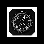
+TotemLake Posted July 25, 2004 Share Posted July 25, 2004 Not to start a debate on real electronic floating compasses versus standard compasses. I use the mapping function until I get down to around 50 feet, then I switch to the electronic 3-axis floating compass on my MeriPlat. I've successfully used it to triangulate as well as point me in a more direct route. The beauty of the electronic compass built into the GPSr (at least for the MeriPlat) is it's ability to point out the bearing you're walking, the direction you're facing, and the bearing of the cache location when used as a GOTO waypoint as noted in this picture below. Quote Link to comment

Recommended Posts
Join the conversation
You can post now and register later. If you have an account, sign in now to post with your account.
Note: Your post will require moderator approval before it will be visible.